Sharjah shows scientific genius of Islamic Golden Age
- Last updated: May 20, 2025 | 14:43 ..


Gulf Today, Staff Reporter
From Arabia to Southern Europe, through the Levant, Egypt and North Africa, eastward to Transoxiana, Sindh and India, Muslim travellers and scholars of the Islamic Golden Age embarked on journeys that transcended mere exploration.
Their meticulous records, spanning trade routes, cultural practices, and geographical wonders, laid the foundation for the ‘Ilm al-Masalik wa al-Mamalik (Science of Roads and Kingdoms), a pioneering branch of Islamic geography that blended administrative precision with intellectual curiosity.
Now, Sharjah’s House of Wisdom celebrates this legacy through its exhibition ‘Chapters of Islamic Art: Travelogues’, running until 5 July 2025.
13 centuries of exploration
The exhibition showcases 13 centuries of exploration through the manuscripts and books of renowned Muslim explorers who travelled across vast distances, circumnavigating the seas; driven by an insatiable curiosity and a passion for discovery and knowledge.
On a journey that traces back the evolution of geography and cartography, visitors will be able to view rare manuscripts, hand-drawn maps and detailed scenes, offering the opportunity to learn about Ibn Battuta's three-decade travels, Ibn Jubayr’s diaries that recorded his observations across Jerusalem, Egypt, Hijaz, Najd, and Iraq; among others.
The exhibition also explores Al-Yaqoubi’s geographical perceptions, and highlights the incredible contributions to navigation by Ibn Majid, who relied on the stars to determine directions on the open seas.
The history of cartography
A key highlight of the exhibition is a chronological experience that takes visitors to the 12th century AD, showcasing the brilliance of Muslim geographer Al-Sharif Al-Idrisi. His renowned ‘Inverted’ or South-Oriented Map, which is oriented with the south at the top in line with the prevailing tradition of honouring Makkah as the centre of the world, was not only a geographical and artistic marvel but also an ambitious scientific project commissioned by the Norman King Roger II of Sicily to draw a precise map of the world.
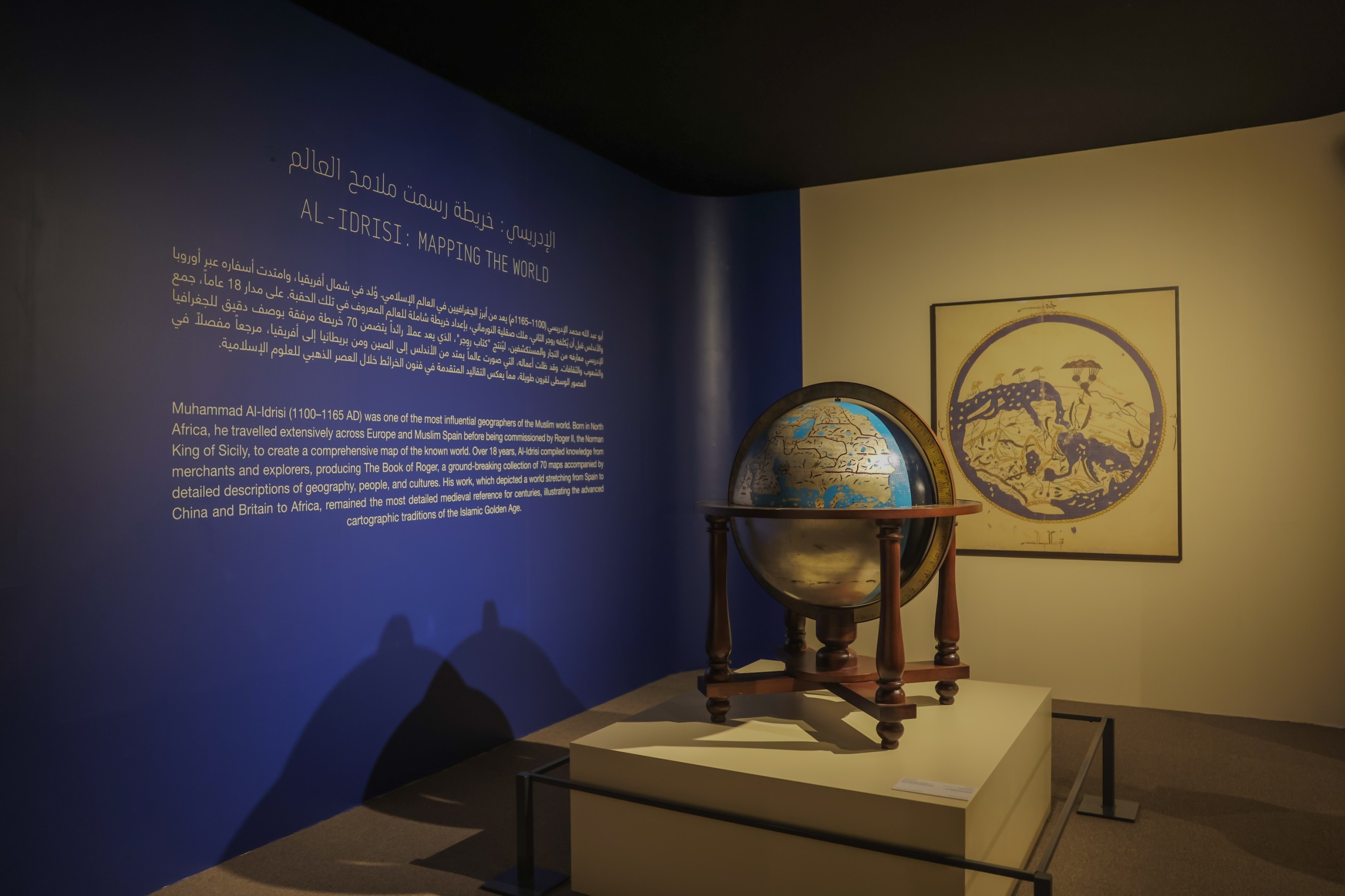
It is considered to be one of the most significant cartographic achievements of the medieval ages, given the stunning detail that made it one of the first scientific attempts to map the world on a systematic and methodological basis.The chronological timeline continues through the 14th to 16th centuries, a key period in cartography, marked by a shift from south-up to north-up orientation. The change was influenced by the translation of Ptolemy’s ‘Geographia’, as well as the discoveries of Columbus, Vasco da Gama, and other European explorers.
From the 16th to the 19th centuries, the exhibition explores advancements in precise measuring instruments such as telescopes, theodolites, and marine chronometers, highlighting their impact on improving cartographic accuracy. The 20th century saw the new surge of aerial photography, remote sensing technologies and satellite imaging, which provided the first space-based full images of Earth from outer space, and thanks to innovations, digital cartography has become a vital tool for urban planning, environmental monitoring, and global communication.
The Third Millennium and the Digital Age
At the beginning of the 21st century, Google Earth and Geographic Information Systems (GIS) reflected the pinnacle of modern geography. These tools transformed cartography from eye-witness accounts to the digital world which relies on tools like satellite imagery and LiDAR scanning to provide high-resolution 3D mapping for Earth’s surface, in addition to AI technology that enabled AI data processing to offer real-time data analysis.
This leap in development created new horizons for global exploration, and transformed geography into a universally accessible resource of knowledge. Google Earth allows users to reorient maps with the south on top, echoing Al-Idrisi’s 12th-century ‘Inverted’ or South-Oriented Map. Exploration has evolved from physical travel to virtual journeys that transcend borders, offering immersive access to the vast expanse of human knowledge.
Featuring four sections, namely; ‘Journeys in Ink: The Art of Islamic Travel and Geographic Literature’; ‘Al-Idrisi: Mapping the World’; ‘Navigating the World: Tools of the Trade’; and ‘From Scrolls to Screens: Travel and Mapping in the 21st Century’, the exhibition is held in collaboration with Dr. Sultan Al Qasimi Centre, the Sharjah Museums Authority, the Manuscripts House in Sharjah, and the King Faisal Center for Research and Islamic Studies in Saudi Arabia.
‘Chapters of Islamic Art: Travelogues’ bridges the past and present, proving that curiosity knows no borders, and by highlighting the legacies of Muslim explorers and cartographers, Sharjah’s House of Wisdom invites the public to see geography not just as maps, but as a testament to humanity’s timeless quest for connection and understanding.