5.3 magnitude earthquake hits Pakistan’s Khyber Pakhtunkhwa and Gilgit-Baltistan
The earthquake had a depth of 180 kilometres with the epicentre in the Afghan-Tajik border.
|
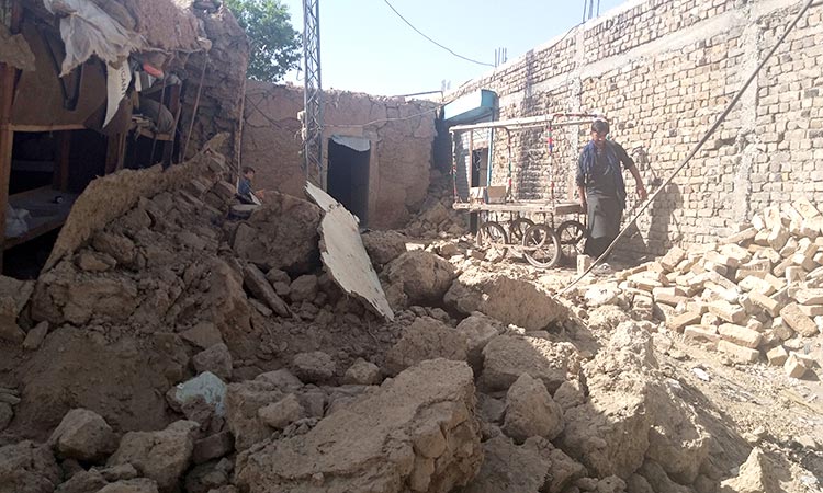
A 'moderate' 5.3 magnitude earthquake rattled parts of Pakistan including Khyber Pakhtunkhwa, Gilgit-Baltistan and Islamabad on Saturday, Dunya News reported. The Pakistan National Seismic Monitoring Centre (NSMC) confirmed the earthquake, with an intensity of 5.3 on the Richter Scale, hit Swat, Peshawar, Lower Dir, Swabi, Nowshera, Islamabad and other cities, forcing people to flee their homes in panic. The monitoring centre said that the earthquake had a depth of 180 kilometres with the epicentre in the Afghan-Tajik border. Earlier on Dec.24, an earthquake of 4.2 magnitude had hit Swat and other areas of Khyber Pakhtunkhwa. The earthquake had a depth of 226 kilometres with the epicentre in the Hindu Kush mountain range, according to the monitoring centre. The cities from Karachi to Islamabad, Quetta to Peshawar, Makran to Abbottabad and Gilgit to Chitral are all affected by the quake, with Kashmir and Gilgit-Baltistan being the most sensitive areas. Pakistan is the fifth most earthquake prone country in the world. Pakistan is located on the northern border of the Indian plate where it meets the Eurasian plate. The sinking of the Eurasian plate and the advancement of the Indian plate has been going on for millions of years. All fault lines running under two-thirds of Pakistan's territory are operational, where intermittent or moderate arthquakes occur intermittently, the report said. |